Fishing:
Local fishing guides report that the trout and kokanee bite has been good this spring. Bring your rods, tackle and a cooler and drop a line while enjoying the view of Goat Mountain. Too much boat traffic on the water for fishing? Head up Willow Creek and try your luck in one of the many great fishing holes.
Hiking:
There are lots of different hiking trails in the area offering a wide variety of experience. Be sure to pack plenty of water and wear appropriate footwear.
Willow Creek and Angel Falls: This is one of the most strenuous hikes around Bass Lake. The trail begins at the Falls Beach on North Shore Road and winds up the mountain along Willow Creek for 2.7 miles, ending at McLeod Flat Road. The two main attractions on this hike are Angel Falls and Devils Slide. Use extreme caution on this hike. Rocks can be extremely slippery and the creek itself hold multiple whirlpools. There have been numerous injuries and even some deaths.
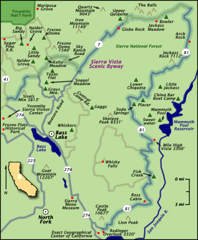
Goat Mountain/Spring Cove: On the south side of the lake, Goat Mountain fire lookout is accessible via the Spring Cove Trail and the Goat Mountain Trail. The Goat Mountain Trail begins in the Forks campground. The Spring Cove trail begins on the east side of Spring Cove campground. Both trails intersect in about an 1/8th of a mile.
Way of the Mono Trail: This is one of the most popular and most used trails. The self guided loop is about 1/2 mile long, offering a great vista point to view the lake. Signs along the trail describe who the Mono people were and how they lived. The trail begins across from the Little Denver Church Day Use Area.
Browns Ditch Trail: Although not an official trail, this 2.5 mile route is clear and very easy to walk. Browns Ditch is the cement flume that brings water to the lake. The route begins where Road 274 meets Central Camp Road and runs along the flume. At points you must walk on the steel walkway over the water. DO NOT ATTEMPT TO ENTER THE WATER. The fast current and steep walls make it dangerous.
Museums
Take in some of our local Madera County history at one of our many museums. These musuems are all within a quick 10-20 minute drive from Bass Lake:
Coarsegold Historic Museum, 31899 Highway 41, Coarsegold
Fresno Flats Historical Park, 49777 Road 427, Oakhurst
Kings Vintage Museum, 40680 Highway 41, Oakhurst
Sierra Mono Museum, 33108 Road 228, North Fork
Yosemite Mountain Sugar Pine Railroad/Thornberry Museum, 56001 Highway 41, Fish Camp
Sierra Vista Scenic Byway
Golfing
There are two very nice golf course near Bass Lake.
Sierra Meadows: 46516 Opah Drive, Oakhurst
River Creek: 41709 Road 600, Ahwahnee
Both courses offer pro shops and cafes.
If you're in the mood for a challenge take the drive up to Wawona and try your luck on the famous Wawona Golf Course. The course is located in Wawona next to the historic Wawona Hotel.
No comments:
Post a Comment